
The final stretch of Denmark’s longest mediaeval road stretched out along a causeway, the polished stones leading to what was once been an island and home today to the ruins of Kalø Castle. It was built some seven centuries ago, an impenetrable fortress to protect a King not necessarily from the threat that might come from overseas, but in the aftermath of a peasants’ revolt; a testament in stone to the paranoia and insecurities of an unloved ruler.
Over the centuries the importance of the castle waned. For a while it was a prison. Then a stately home. Since the 17th century it has been slowly crumbling, and today it is a place that attracts day-trippers and birdwatchers, those curious about the history of this corner of Denmark and those who simply like the idea of crossing a causeway to reach an island.
On the way back we take in the rest of our surroundings. Across the curve of the bay we see the low hills of the Mols Bjerge against the sky. Heading into the hills, we move into a landscape long been shaped by human hands. Initially formed during the Ice Age, this moraine landscape was left behind as the ice retreated. Stone Age settlement followed. where graves were dug and chieftains buried. The hills continued to be a sacred site into the Bronze Age, and some of them were not a result of the retreat of the ice at all, but burial mounds to give new shape to the landscape.

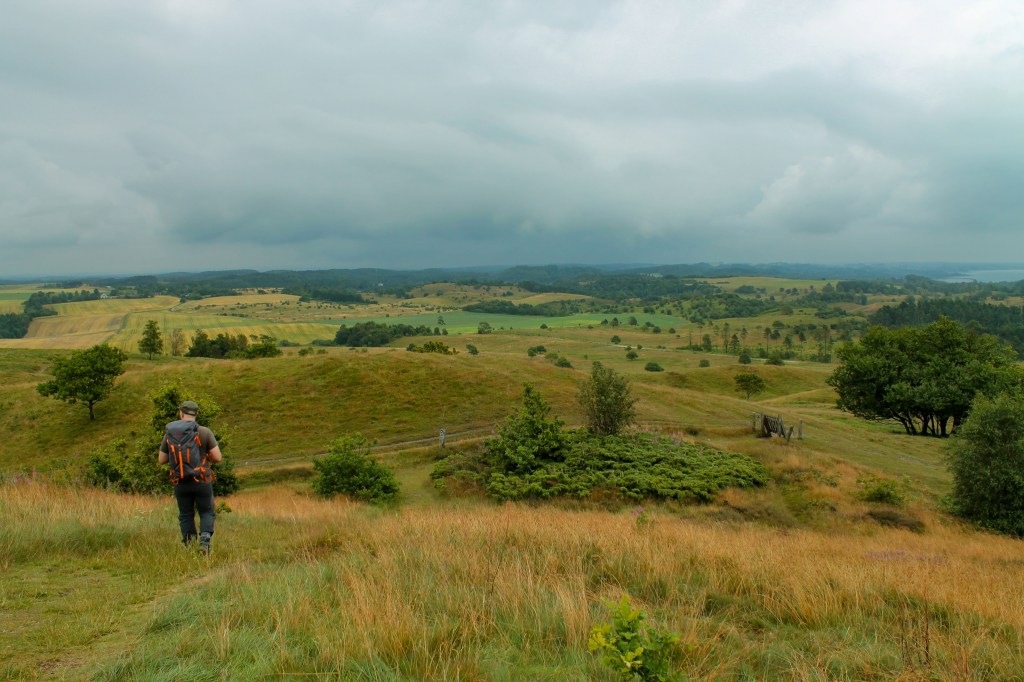
We are aiming for the mounds at Trehøje, 127 metres above sea level and almost the highest point in the Mols Bjerge National Park. White tracks carved out of the grassland lead us there, to a lookout point back down towards the bay and the castle, with the harbour and tall buildings of Aarhus shimmering in the distance.
This is a rumpled sheet of rolling hills, a grassy moorland speckled with juniper and sloe bushes, with the odd conifer plantation here and there. Cattle grazing has long given the hills their bleak and bare look, but appearances can be deceptive. Today, the Mols Bjerge contains almost half of all of Denmark’s wild plant species, with all manner of bird and other wildlife calling the park home. These might be modest as mountains go, but have their own beauty, a place shaped by stories contained in the earth, the cobblestones of an ancient road and the tracks along which the dead once made their final journey.
Why travel to the Mols Bjerge?
There is a quiet beauty to this corner of the world. It’s not about high mountains or dramatic coastlines of course, but it has a lot to do with the stories contained among its gentle hills. The Mols Bjerge National Park covers a remarkably diverse landscape, shaped by the end of the last Ice Age, and contains around a quarter of Denmark’s conservation-worthy habitat sites and supports about half of its wild plant species. So you can explore a mix of old woodlands, open heath dotted with juniper bushes and coastal meadows where it can sometimes be hard to see where the land ends and the water begins.

The town of Ebeltoft is a good base for exploring the park and is quite lovely in its own right. The old town has a mix of half-timbered houses lining cobbled streets, while the harbour is home to the world’s longest wooden warship. There are some great little cafes and shops hidden along the narrow alleyways or in courtyards of the town, and we found a fascinating museum that told the story of blue dying techniques. Indeed, the Old Dyers Yard is the only remaining traditional dye works in all of Northern Europe.
Depending on the time of year, there are plenty of activities in and around the Mols Bjerge National Park to get involved in. As well as hiking, covered in the next section of our mini-guide, this is a great place for cycling, whether on the roads or the mountain bike trails, or getting out on the water for a spot of kayaking or windsurfing. The tourism website has a downloadable kayaking map for the area (Danish language only).
Favourite walk in the Mols Bjerge
The walk we did to the ruins of Kalø Castle along the causeway is an easy 3-kilometre out and back. Indeed, the only slightly worrying moment was having to share the narrow cobbled road with a herd of cows, who for the most part simply ignored the straggle of visitors making their way to the castle. Here is the walk on AllTrails.
For our walk to Trehøje, with fine views across the National Park, we were following a short section of the Mols Bjerge Trail, an 80-km hiking route that has been divided into four stages. Stage one includes Kalø Castle and stage two is the section we walked through the hills to the highest point in the park. There is an overview of the hike in English, including a downloadable route map, on the Mols Bjerge National Park website.
Travel tips for the Mols Bjerge
We stayed at Sølystgård Camping, south of the hills and across the bay from Ebeltoft. The campsite was quite big but even in summer we were able for find a spot pretty much to ourselves. Unusually for Denmark, the campsite is on some quite hilly ground and laid out on a number of levels, which means it is possible to get a pitch with some fine sea views (facing east, for the sunrise) and we even watched another traveller get his paraglider launched from the hill above the beach.
The campsite has a small shop and pretty good facilities, and seems quite popular with families without being overrun. Ebeltoft itself has a range of accommodation options, and the Mols Bjerge are also well within day-trip range from nearby Aarhus, a city well worth visiting in its own right. We had our own vehicle when we were there, which was quite useful for getting around the different places in the park. There is a bus (No.123) from Aarhus via Rønde to Ebeltoft. It stops at a number of trailheads as well as the Kalø Castle ruins.
You can see the bus route, as well as other important landmarks for the Mols Bjerge National Park, on this interactive map.

Words by Paul Scraton
Photographs by Katrin Schönig
